
EVENT: March 9, 1957 Aleutian Islands Earthquake and Tsunami—On March 9, 1957, a magnitude 8.6 Mw earthquake along the Aleutian Islands generated a tsunami. The earthquake and tsunami damaged several nearby Aleutian Islands, including significant impact on Adak Island. Recent surveying has revealed that tsunami waves reached as high as 32 meters (over 100 feet) at the coast of Unalaska Island. The Hawaiian Islands were severely impacted by the tsunami waves, sustaining over $5 million (1957 USD) in damage. The tsunami waves reached 10, 5, 9, and 16 meters on Hawai‘i, Maui, O‘ahu, and Kaua‘i, respectively, causing damage on each island. A reporter and a pilot trying to cover the tsunami’s arrival were killed when their small plane crashed in the ocean near O‘ahu. The tsunami also caused damage along the coasts of Japan, North America, and Central America. Reaching the far corners of the Pacific, the tsunami was recorded as far as 8,500 miles away in southern Chile and 6,200 miles away in Australia.
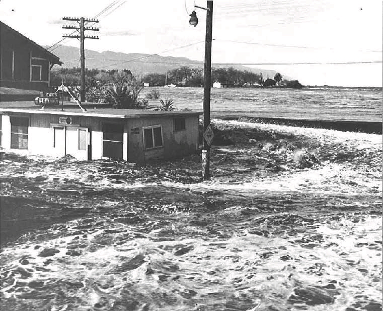
PHOTO DETAILS: Waialua Bay, Oahu, Hawaiʻi First big wave breaks over seawall, Waialua Bay, Oahu. 3.9 m runup (~12-ft wave). Image courtesy of R. Nakamura, Honolulu Star-Bulletin and International Tsunami Information Center (ITIC). https://www.ngdc.noaa.gov/hazardimages/#/tsunami/291/image/2295
More images from this event are available in the NCEI Natural Hazards Image Database. Any parties interested in contributing photographs to this free and public resource may contact NCEI for submission requirements at haz.info@noaa.gov or Lindsey Wright at lindsey.m.wright@noaa.gov.
Link to NCEI Natural Hazards Image Database: https://www.ngdc.noaa.gov/hazardimages/#/
