
By FEMA Region 10
With hundreds of miles of coastline along Alaska, Oregon and Washington, these states are left vulnerable when a tsunami strikes.
Now, there’s a new comprehensive, first-of-its-kind national assessment of the risk from earthquake-generated tsunamis from the Federal Emergency Management Agency (FEMA) to better help these low-lying, coastal communities. The assessment or study – FEMA P-2426: Estimated Average Annualized Tsunami Losses for the United States – highlights the significant tsunami risks faced by coastal communities in U.S. states and territories, including potential losses of life. It is estimated that tsunamis generated by earthquakes could cause an average of over $1 billion in damage per year, highlighting a significant threat.
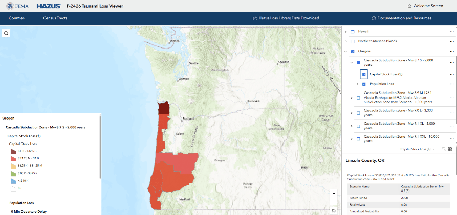
Emergency managers in coastal communities can use this study to make informed decisions for their communities. By analyzing their tsunami risks, they can reduce building risks and create evacuation strategies to save lives. FEMA and its partners have published the data and results from the study in multiple formats so that communities can use the information in a way that best works for them.
To support coastal communities, FEMA also developed these user-friendly tools:
- Tsunami Loss Viewer: This map-based tool lets users explore tsunami results, including annualized loss results at the census tract and county levels. Communities can use this to visualize their risk, identify vulnerable areas and inform local planning for saving lives after a tsunami.
- Updates to the Hazus Loss Library: The Hazus Loss Library now includes data that includes over 100 new tsunami scenarios and analyses. This equips local planners and emergency managers with detailed data to integrate into their own analyses, supporting local mitigation planning and a deeper understanding of potential building losses.
This study marks a milestone in understanding the nation’s tsunami risk, developed through extensive collaboration with state, territorial and federal partners like the U.S. Geological Survey, National Oceanic and Atmospheric Administration and the National Tsunami Hazard Mitigation Program. By using improved data and methods, it offers a more accurate and actionable picture of tsunami risk for local decision-makers and emergency managers.
The new tool complements recent support with which FEMA Region 10 has emboldened communities to take steps that make them more resilient to disasters like tsunamis. This includes funding for two tsunami siren projects in Alaska and vertical evacuation structures in Westport, Washington and the Native Village of Ouzinkie. These projects expanded on past successes like the Auntie Lee Vertical Evacuation Structure built by the Shoalwater Bay Indian Tribe. The completed 2022 project provides an evacuation point for tribal members and members of the neighboring Tokeland, Washington community. Upon completion, these projects will make communities more resilient to tsunami threats and save lives. FEMA Region 10 is extending their collaboration efforts with partners to help develop and improve state focused tsunami hazard assessments. This will help Alaska and Washington consider local factors that are unique to each region that may not be shown on the national-scale assessment.
Suggested citation: FEMA Region 10, August 2026, Preparing for the Next Wave – Partnerships that Reduce Tsunami Risks: TsuInfo Alert. https://tsuinfoalert.blog/2026/08/24/preparing-for-the-next-wave-partnerships-that-reduce-tsunami-risks/ (accessed MM/DD/YYYY)
 HOME
HOME 